Travel Planner
“Our Favorite Parks From the Last 20 Years”
Episode #2010 Travel Planner
Celebrating 20 years of Great Getaways we count down our favorite parks. From southern Ontario to the northern reaches of Michigan and everything in between.
Comments
Tell us what you thought of this episode and get information about the areas featured by filling out the comment form
Comment Form
Michigan / Ontario
Fort Wilkins Historic State Park
Keweenaw County - Michigan
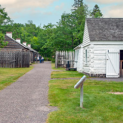
Location: 15223 U.S Highway 41 - Copper Harbor MI, 49918
Size: 700 Acres
Camping: Cabin, 4 Group Use Sites, 159 Modern Campsites
Fort Wilkins Historic State Park, located in the northern tip of the Keweenaw Peninsula, features a modern campground, trails, a historical fort with a living history program, two 1860s lighthouses on Lake Superior and much more.
Visitors will enjoy a quarter-mile of rocky Lake Superior shoreline, Lake Fanny Hooe and a quarter-mile of sandy beach on Lake Manganese. The park features a restored 1844 army military outpost, including 19 buildings, with a living history program provided by the Michigan History Center. Visitors can experience a look back at life on the northern frontier during the mid-1800s and a time when soldiers were stationed in Michigan's Upper Peninsula.
- Fort Wilkins Historic State Park [Michigan DNR]
Harrisville State Park
Alcona County - Michigan
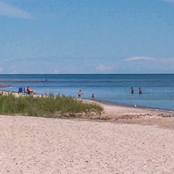
Location: 248 State Park Rd - Harrisville, MI
Area: 107 acres
Phone: (989) 724-5126
Harrisville State Park features a campground and day-use area nestled in a stand of pine and cedar trees along the sandy shores of Lake Huron. The park is within walking distance of the resort town of Harrisville and it's many events and close to Sturgeon Point Light House.
- Harrisville State Park [Michigan DNR]
Sturgeon Point State Park
Alcona County - Michigan
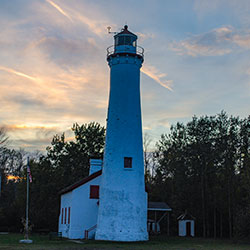
Location: 6036 Point Rd, Harrisville, MI 48740
Phone: (989) 727-4703
Sturgeon Point State Park juts into Lake Huron, and waves off the Point conceal a long and shallow reef which extends for almost a full mile beyond the visible confines of the land. This undeveloped site offers parking for visitors interested in visiting the lighthouse and museum that rests on the property. The Alcona Historical Society is responsible for upkeep on the light that is owned by the US Coast Guard.
- Sturgeon Point State Park [Michigan DNR]
Negwegon State Park
Alpena/Alcona Counties - Michigan

Location: Ossineke, MI
Contact: Harrisville State Park (989) 724-5126
Hours: Open year round
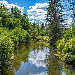
Negwegon State Park is a rustic, undeveloped area open for hunting, walk-in camping and hiking. The terrain is a mixture of low land areas, with small ridges, to mature pine forest, with some hardwoods and aspen forest, with some pockets of open meadows mixed in. Negwegon hosts a beautiful undeveloped sandy beach on Lake Huron. Please use caution when visiting Negwegon as the roads into the park are often so sandy that a four-wheel drive vehicle is needed. Motorized vehicles are not allowed on the trails or off-road.
- Negwegon State Park [Michigan DNR]
- Negwegon State Park Map 972kb
- Negwegon State Park Backcountry Guide 274kb
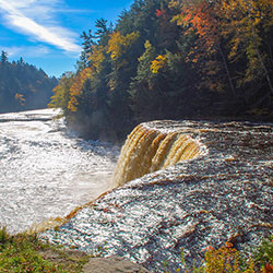
Tahquamenon Falls State Park
Chippewa County - Michigan
Location: 41382 W. M 123 - Paradise MI, 49768
Size: 46,179 Acres
Camping: 3 Backcountry Campsites, Group Use Area, Lodge, Camper Cabin, 260 Modern Campsites, 36 Semi-Modern / Rustic Campsites
Tahquamenon Falls State Park encompasses nearly 50,000 acres and stretches 13-plus miles in Michigan's Upper Peninsula. The park is home to multiple campgrounds, overnight lodging facilities, a boat launch, more than 35 miles of trails and multiple overlooks to the Upper and Lower Falls.
The 200-feet-wide Upper Falls is one the largest waterfalls east of the Mississippi River. The river’s amber color is caused by tannins leached from the cedar, spruce and hemlock trees in the swamps drained by the river, and the extremely soft water churned by the action of the falls causes the river’s trademark large amounts of foam. Just 4 miles downstream is the Lower Falls, consisting of a series of five smaller falls cascading around an island. The falls can be viewed from the riverbank, all-accessible Ronald A. Olson Island Bridge over the Tahquamenon River or by a rowboat rented from a park concession. Drone use is prohibited.
Black bear, coyote, otter, deer, fox, porcupine, beaver and abundant bird life, including spruce grouse, pileated woodpeckers, bald eagles and a variety of waterfowl and songbirds can be found in the park. Moose are occasionally seen feeding in the wet areas of the park, especially along M-123 between Paradise and the Lower Falls.
- Tahquamenon Falls State Park [Michigan DNR]
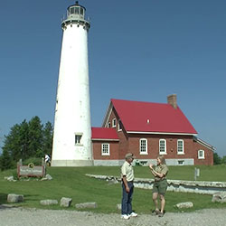
Tawas Point State Park
Iosco County - Michigan
Location: 686 Tawas beach Road - East Tawas, Michigan
Size: 183 Acres
Phone: (989) 362-5041
Tawas Point has been referred to as the "Cape Cod of the Midwest." The campground is located on Tawas Bay where the water is shallow and warm for swimming. In the park is the Tawas Point Lighthouse which serves as the sole representative of a true Victorian-era style station on the Great Lakes. The park’s expansive day-use beach offers acres of glistening white sugar sand, sprinkled with patches of dune grass and backed by low dunes on the Lake Huron side.
- Tawas Point State Park [Michigan DNR]
- Tawas Point State Park [Michigan DNR | 162kb]
South Higgins Lake State Park
Roscommon County - Michigan
Location: 106 State Park Drive - Roscommon, MI 48653
Phone: (989) 821-6374
1000 acre park with almost one mile of shoreline along Higgins Lake. 400 modern, hardwood-shaded campsites, a mini-cabin, sandy beach, fishing, boat launch, picnic area. Self-guided nature trail. Ungroomed trails for cross-country skiing and hiking. Rowboat, canoe, paddleboat, small motorboat and pontoon rentals. Ice fishing. Metal detecting area.
- South Higgins Lake State Park [Michigan DNR]
- Trail Map [Michigan DNR 252kb]
Indian Lake State Park
Schoolcraft County - Michigan
Location: 8970 W County Road 442 - Manistique MI, 49854
Size: 567 Acres
Camping: 145 Modern Campsites, 72 Semi-Modern Campsites, 2 Mini Cabins
Indian Lake State Park is located on the shores of Indian Lake, five miles west of Manistique in Michigan’s Upper Peninsula. This 567-acre park is composed of two units, which are 3 miles apart and separated by the lake. The south unit features a modern campground overlooking the lake and the west unit features semi-modern campsites in a wooded setting. Other amenities include two Civilian Conservation Corps-era picnic shelters, a designated swim beach, a quarter-mile, paved trail along the lake and boating access site.
Indian Lake, which is 6 miles long and 3 miles wide, is the fourth-largest inland lake in the Upper Peninsula. The lake was once called M'O'Nistique Lake, and surveyor records from 1850 indicate Native Americans lived in log cabins near the outlet of the lake.
- Indian Lake State Park [Michigan DNR]
Palms Book State Park
Schoolcraft County - Michigan
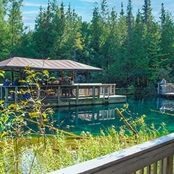
Location: M-149 (a mile north of the Co Rd 455 junction) - Manistique MI, 49854
Size: 388 Acres
Palms Book State Park, located at the north end of Indian Lake in Michigan's Upper Peninsula, is home to Kitch-iti-kipi or "The Big Spring." This renowned natural attraction is Michigan’s largest freshwater spring with more than 10,000 gallons of water per minutes gushing through fissures in the underlying limestone at a constant 45 degrees Fahrenheit. By means of a self-guided (accessible) observation raft, visitors can view this crystal-clear pool with an emerald green bottom.
Concessions and souvenirs are available at a store open seasonally and a boating access site provides access to Indian Lake (the Upper Peninsula’s fourth-largest inland lake).
The observation raft if open 8 a.m. to dusk. It's prohibited to swim, bathe, skin or scuba dive, fish, boat, enter, or place or launch any object (including underwater cameras) in the "The Big Spring," or use the raft for anything other than viewing.
- Palms Book State Park [Michigan DNR]
Fayette Historic State Park
Delta County - Michigan
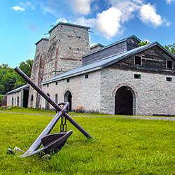
Location: 4785 II Road - Garden MI, 49835
Size: 711 Acres
Camping: 1 Lodge, 61 Modern Campsites
Find unmatched scenery and take a walk back in time at Fayette Historic State Park. Blending history and nature, the park is located on the shores of Big Bay de Noc – on Lake Michigan between Snail Shell Harbor and Sand Bay – on the southern side of Michigan’s Upper Peninsula.
Visitors will also find a historic townsite, a modern campground, Snail Shell Harbor, a visitor center, a boating access site, a designated swim area and more. The park’s 5 miles of trails offer impressive views from 90-foot limestone cliffs that surround the harbor.
Fayette Historic Townsite represents a once-bustling industrial community that manufactured charcoal pig iron between 1867 and 1891 at the tip of the Garden Peninsula. Visitors may walk through the well-preserved buildings that have been standing for 150 years and learn about life during the 19th century. There are self-guided and guided tour options (summer months only) available.
- Fayette Historic State Park [Michigan DNR]
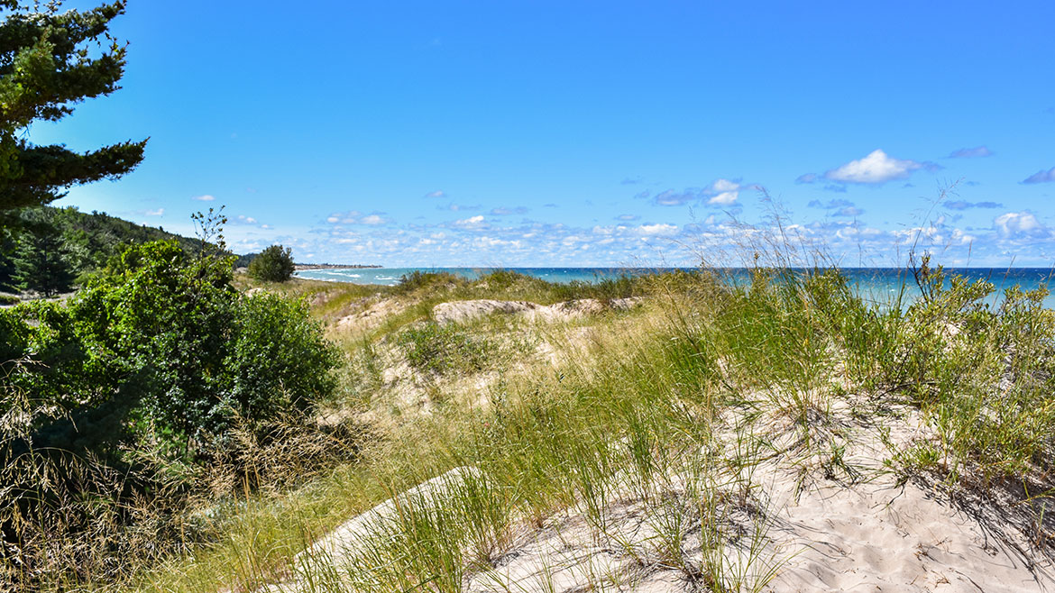
Nordhouse Dunes Wilderness Area
Mason County - Michigan
Location: Lake Michigan Shore, North of Ludington State Park (44.087486, -86.444676)
Size: 3,450 acres of National Forest
Phone: Cadillac / Manistee Ranger District (231) 723-2211
The Nordhouse Dunes Wilderness Area is a Federally designated wilderness in Michigan's lower peninsula and encompasses 3,450 acres of National Forest. The wilderness area is popular for hiking, camping, hunting, nature study and wildlife viewing. There are approximately 10-miles of trail that can be accessed from 2 developed trailheads at the end of Nurnberg Road and Lake Michigan Recreation Area.
- Nordhouse Dunes Wilderness Area [Huron Manistee National Forests]
- Nordhouse Dunes Wilderness Area [US Forest Service 5.35mb]
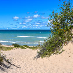
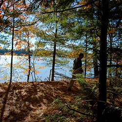
Ludington State Park
Mason County - Michigan
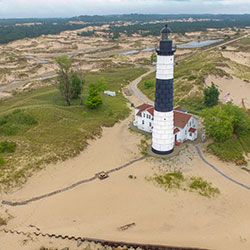
Location: 8800 W. M-116 - Ludington, MI 49431
Size: 5300 Acres
Phone: C(231) 843-2423
Hiking Trails: 21.50 Miles
Ludington State Park is a favorite destination for hikers, fisherman, bikers, paddlers and campers. The park is home to three campgrounds, scenic sand dunes, an iconic lighthouse, marshlands, beaches and hardwood forests. The park is situated between seven miles of Lake Michigan shoreline and Hamlin Lake.
Ludington State Park is comprised of scenic sand dunes, beaches, an iconic lighthouse, ponds, marshlands and forests. It is situated between Hamlin Lake and Lake Michigan with several miles of shoreline and beaches on both bodies of water.
- Ludington State Park [Michigan DNR]
- Ludington State Park - Map [Michigan DNR 230kb]
- Ludington State Park Hiking Trails [Michigan DNR 295kb]
Rifle River Recreation Area
Ogemaw County - Michigan
Location: 2550 E Rose City Road - Lupton, MI 48635
18 Miles NW of West Branch on Rose City Road (AuSable State Forest)
Approximate Size: 4449 Acres
Trails: 14 Miles
Phone: (989) 473-2258
The Rifle River Recreation Area covers over 4,000 acres in Ogemaw County. The park offers 159 campsites, has several hiking trails and several lakes in its boundaries. Also in the watershed are two state forest campgrounds. The Rifle River campground provides 40 campsites and is located on both sides of the Rifle River. Hardwood Lake State Forest Campground has 22 campsites available. Public canoe access to the Rifle River is fairly good. Access sites are located in the Rifle River Recreation Area, the state forest campground, near Skidway Lake, Moffatt Bridge, and at Omer. In addition, there is a partially developed access site near the confluence of Klacking Creek with the Rifle.
- Rifle River Recreation Area [Visit West Branch]
Colwell Lake Trail
Schoolcraft County - Michigan
Location: 30 Miles North of Manistique just off of M-94
Colwell lake is 145 acres with an excellent swimming beach and boat access. Camping, fishing, picnicking and hiking are other popular recreation activities at Colwell Lake. The Colwell Lake Trail begins at the boat launch parking lot. This natural surface, nature trail is 1.6 miles long and crosses through a variety of northern hardwood stands and wetlands. The trail has several areas where stairs or plank boardwalks are traversed.
- Colwell Lake Hiking Trail [Hiawatha National Forest]
- Colwell Lake Trail Map [Visit Manistique]
Shiawassee National Wildlife Refuge
Saginaw County - Michigan
Location: 6975 Mower Road - Saginaw MI
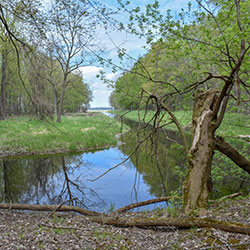
Shiawassee National Wildlife Refuge is provides a habitat for migratory waterfowl. Known locally as the "Shiawassee Flats," the refuge lies in the Saginaw Bay watershed, historically one of the largest and most productive wetland ecosystems in Michigan. Four rivers converge on the refuge - the Tittabawassee, Flint, Cass, and Shiawassee. The refuge offers several trail systems that highlight the unique features of the area. Trails are open year round, seven days a week, during daylight hours except for days during hunting periods. The Woodland Trail, located off of Center and Stroebel Roads on the north side of the refuge, offers over 4.5 miles of trails. The Ferguson Bayou Trail, located at the west end of Curtis Road on the south side of the refuge, offers over 4.5 miles of trails. The Wildlife Drive (Auto Tour Route) meanders past forests, grasslands, marshes, open water pools, and the Shiawassee River.
- Shiawassee National Wildlife Refuge [Go Great Lakes Bay]
- Shiawassee National Wildlife Refuge | Trails [US Fish & Wildlife Service]
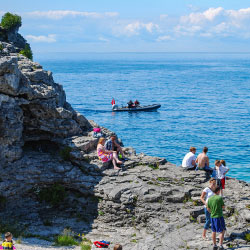
Fathom Five National Marine Park
Bruce County - Ontario
Location: 121 Chi sin tib dek Rd, Tobermory, ON N0H 2R0, Canada
Size: 43 sq mi
Phone: +1 519-596-2233
In the traditional territory of the Saugeen Ojibway Nation, this park has sparkling blue water, rugged shoreline scenery and the famous Flowerpot Island rock formations. World renowned scuba diving on 24 shipwrecks, in the heart of the Great Lakes.
- Fathom Five National Marine Park of Canada [Parks Canada]
Porcupine Mountains Wilderness State Park
Ontonagon County - Michigan
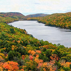
Location: 33303 Headquarters Road - Ontonagon MI, 49953
Size: 59,020 Acres
Camping: 64 Rustic Campsites, 65 Backcountry Campsites, 19 Rustic Cabins, 100 Modern Campsites, 4 Yurt Campsites, Modern Lodge, 2 Group Sites
Porcupine Mountains Wilderness State Park – fondly known as "the Porkies" – features 60,000 acres of old-growth forest, roaring waterfalls, Lake Superior shoreline, rivers, trails and ridges. The park’s incomparable vistas make Michigan’s largest state park a popular destination for camping, hiking, snowmobiling, fishing and more. The park boasts many popular natural attractions, including Lake of the Clouds and the scenic Presque Isle River corridor. Other attractions include the Summit Peak observation tower, Porcupine Mountains Winter Sport Complex, fall chairlift rides, an 18-hole disc golf course and more.
- Porcupine Mountains Wilderness State Park [Michigan DNR]